MARCO PAVARINUfficio educazione naturalistica e comunicazione del Parco Regionale dei colli euganei
Tra rocce, natura e uomoGEOLOGIA E AMBIENTEFormazione ed evoluzione delle rocce e dei terreni
|
|
L'area euganea costituisce un esempio singolare e probabilmente unico di come le vicende geologiche, l'evoluzione dell'ambiente naturale e la secolare presenza antropica siano intrecciate a tal punto da non poter essere studiate e comprese separatamente l'una dall'altra.
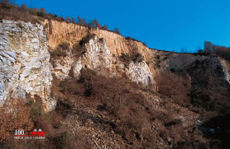
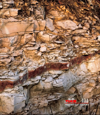
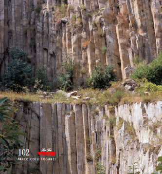
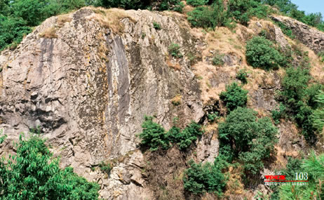
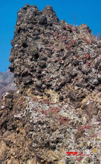
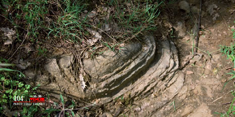
Autentico laboratorio didattico di geologia a cielo aperto, i Colli emergono dalla pianura quasi a far da prologo alle poco distanti pendici beriche e prealpine; con esse condividono parte della storia di un antichissimo mare che nell'Era Mesozoica, copriva buona parte dell'area. Le rocce più antiche in affioramento sono di natura sedimentaria. Il Rosso Ammonitico, calcare risalente al Giurassico (circa 150 milioni di anni fa), prende il nome dalle ammoniti, molluschi marini, con conchiglia a spirale, ora estinti; formazione rocciosa rara sugli Euganei, affiora solo a Cinto Euganeo, nei pressi della frazione di Fontanafredda. In sequenza temporale sopra di esso, giacciono a strati le altre formazioni sedimentarie, via via più recenti. Il Biancone, calcare chiaro a grana finissima, è diffuso nella zona di Villa di Teolo, nei dintorni di Bastia e Fontanafredda. Anche se molto differenti come aspetto, a questa formazione appartengono porzioni di una più tenera roccia di colore scuro (argillite), portate alla luce presso Cava Bomba a Cinto Euganeo, nella quale sono stati ritrovati importanti reperti fossili di antichi ambienti tropicali marini; essi sono esposti nel Museo della Provincia di Padova presso Cava Bomba, nei suggestivi ambienti dell'omonimo complesso di archeologia industriale, ex fornace da calce ora dismessa. Al Biancone segue la Scaglia Rossa, calcare argilloso di colore più o meno rosato e fittamente stratificato; essa si formò dalla deposizione in mare tra il Cretaceo superiore e l'Eocene inferiore, quindi oltrepassando il limite tra l'Era Mesozoica e la successiva Era Cenozoica o Terziaria. Comunemente chiamata "scaglia" è certamente la più diffusa e conosciuta tra le rocce sedimentarie euganee, soprattutto nell'area tra Cinto Euganeo, Valle S. Giorgio, Baone ed Arquà Petrarca. Dalle cave di scaglia, ora non più attive, provengono varie specie fossili, tra cui abbondano i ricci di mare e i denti di squalo. Materiale di origine marina molto diffuso e incluso nelle rocce sedimentarie, in particolare Biancone e Scaglia, è la selce, di colore grigio, nero e di varie tonalità di rosa; essa venne utilizzata dagli antichi abitanti delle pendici collinari che seppero sfruttare sapientemente le sue proprietà per realizzare strumenti adatti al taglio per cacciare e per gli usi quotidiani. In questo territorio collinare, la serie sedimentaria termina con la Marna Euganea. Materiale ricco d'argilla, la marna è assai friabile, tenera e stratificata, di colore per lo più grigio; il periodo di formazione delle porzioni ancora oggi in affioramento arriva fino all'Oligocene inferiore. L'estrazione delle marne, nella zona di Monselice, Rivadolmo e Cinto Euganeo servì in passato alla produzione di cemento. Nell'Era Terziaria cominciarono le grandi trasformazioni dovute ai più conosciuti e caratteristici fenomeni vulcanici che ancor oggi contraddistinguono in modo netto e inconfondibile le linee del paesaggio euganeo. Il vulcanesimo si divise in due fasi nettamente distinte. Le prime attività risalgono all'Eocene superiore (circa 43 milioni di anni fa), quasi contemporaneamente ad altri importanti fenomeni simili che, nell'area prealpina, fecero da corollario ai movimenti di formazione della catena Alpina. Colate sottomarine di lava basaltica, assai fluide e ricche di gas e vapori, si riversarono espandendosi sul piatto fondale dell'antico mare, formando accumuli poco elevati e velocemente solidificati al contatto con l'acqua. Oltre a queste, vi fu una grande quantità di prodotti esplosivi come ceneri e lapilli, che formarono spesse coltri di tufi frammisti alla fanghiglia del fondale. Oggi, ciò che resta di questa prima fase vulcanica si ritrova affiorante soprattutto nel settore centrale dei Colli. Fu solo la seconda fase vulcanica che diede l'impronta attuale al comprensorio euganeo. Dopo un periodo di quiete, all'inizio dell'Oligocene (circa 35 milioni di anni fa) una forte ripresa dei fenomeni produsse materiali lavici di composizione molto diversa rispetto a quelli della fase precedente, a tal punto che questa fu l'unica zona delle attuali Venezie dove fuoriuscirono abbondanti lave acide ricche in silice e assai viscose. Dal raffreddamento nacquero rocce particolari, per prima la riolite seguita da trachite e latite, con filoni di basalto a chiudere il ciclo. La forte spinta dei magmi sollevò e fratturò nei modi più disparati gli antichi strati del fondo marino che, fino ad allora, avevano conservato la conformazione originale. Si formarono di fatto gli apparati che conferiscono alla morfologia euganea un aspetto unico e suggestivo. Colline dolci e più arrotondate, dette laccoliti, sono costituite da un rigonfiamento lavico raffreddato al di sotto di una copertura di rocce sedimentarie più antiche; prendono il nome di laccoliti di eruzione quando il magma continuò la sua spinta fino a sfondare la copertura calcarea stessa. Molte sono le forme ripide e aspre formate dalla fuoriuscita del magma; tra di esse, da ricordare è la spettacolare parete rocciosa trachitica di Rocca Pendice, tra Castelnuovo e Teolo, oggi conosciuta anche per le numerose e articolate vie dedicate all'arrampicata sportiva e, negli ultimi anni, per essere sito protetto di nidificazione spontanea del falco pellegrino. Terminati i fenomeni vulcanici, le cime più alte emersero probabilmente andando a formare nell'antico mare padano un arcipelago di ripidi isolotti pietrosi. Molto tempo dopo, l'emersione dal mare e un'erosione selettiva di milioni di anni hanno prodotto un paesaggio molto vario; le più tenere coperture sedimentarie vennero in parte smantellate dagli agenti atmosferici e, allo stesso modo, furono esposti in netto contrasto visivo i duri corpi vulcanici dai fianchi ripidi e dalle cime coniche. Le vicende climatiche, l'evoluzione della vegetazione e l'insediamento umano hanno in seguito completato l'opera con importanti e decisive trasformazioni. La varia natura geologica dei terreni derivati dal disfacimento in superficie del substrato sedimentario o vulcanico, la morfologia attuale fatta di piccole cime a perimetro chiuso ed esposizione variabile e le caratteristiche ambientali attuali rendono i Colli Euganei un territorio davvero prezioso per la biodiversità. Qui il clima è generalmente più mite rispetto alla pianura, sia in estate che in inverno, con variazioni termiche meno marcate. Così, nei pendii esposti a meridione dove i raggi solari arrivano più diretti e carichi di calore, vegetano molte specie peculiari della flora mediterranea; al contrario, nei freschi e ombrosi versanti settentrionali e nelle strette incisioni vallive formate da corsi d'acqua per lo più temporanei, si insediano specie amanti di climi freschi, alcune di esse lasciateci in eredità da epoche glaciali lontane. La stagione fredda sui Colli è spesso allietata da giornate con aria tersa e serena; se ci si alza di quota, mentre la pianura riposa nella nebbia, si può assistere al suggestivo fenomeno dell'inversione termica, che fa apparire le cime delle colline come isole in un mare di nuvole, quasi a riportare alla mente la distesa d'acqua dell'antico mare che un tempo lontano caratterizzava il paesaggio. Importanti variazioni dipendono, oltre che dalla morfologia e dall'esposizione, anche dall'inclinazione dei versanti e dalla presenza di roccia esposta al sole riflettente i caldi raggi luminosi, come avviene ad esempio nelle numerose cave dismesse. Le attività estrattive hanno lasciato ripide pareti, sia di calcaree e argillose rocce sedimentarie, un tempo sfruttate per produrre calce e cemento, sia di Trachite e altre vulcaniche, importanti materie prime storicamente estratte per la realizzazione di manufatti e pavimentazioni di vie e piazze nelle zone più nobili del centro di Padova, Venezia e molti altri paesi e città del Veneto. Alcune volte queste ferite inferte dalla mano dell'uomo sono state mortali per le colline, irrimediabilmente trasformate o addirittura cancellate dalle mappe; in molti casi, tuttavia, grazie al lento, inesorabile cammino dell'evoluzione naturale e all'aiuto dato con progetti specifici, la vegetazione ha preso possesso di questi particolari ambienti "nuovi" per i Colli Euganei. Specie pioniere di piante e animali colonizzano ora le vecchie cave di roccia e contribuiscono ad arricchirne la biodiversità. Risorsa peculiare dei Colli Euganei, che oltrepassa per fama i confini nazionali, è senza dubbio la presenza di uno dei più importanti ed estesi comprensori termali a livello europeo, nei comuni di Abano Terme, Montegrotto Terme, Battaglia Terme, Galzignano Terme e Teolo. La natura delle acque termali è stata oggetto di studio approfondito attorno alla metà degli anni '70, quando fu possibile ricostruirne l'origine grazie ad un modello di circuito sotterraneo di tipo geotermale e, di conseguenza, venne abbandonata la teoria comune dell'esistenza di un riscaldamento dovuto a magma ancora latente in profondità; il vulcanesimo che ha generato i Colli è troppo antico e ormai esaurito per originare ancora una sorgente attiva di calore. Secondo il modello proposto, le acque derivano da precipitazioni in zone montane nel territorio delle Piccole Dolomiti (Recoaro, Valdagno, M. Pasubio), da dove iniziano una lentissima discesa in sistemi di frattura nelle rocce sedimentarie, raggiungendo una profondità di circa 3000 m. fino ad incontrare un antichissimo basamento cristallino impermeabile. Durante il loro cammino sotterraneo, favorito anche dall'assetto geologico dell'area prealpina e padana, esse aumentano progressivamente la loro temperatura, grazie al calore interno della terra, fino a superare gli 87°C. In prossimità del comprensorio euganeo, la risalita dell'acqua è possibile grazie all'ostacolo fisico che la stessa trova nelle rocce vulcaniche solide e compatte e da una serie di fratture locali che favoriscono meccanismi di pressione idraulica. Arricchite di una leggera radioattività e caricate di vari e preziosi componenti minerali, presenti nelle rocce attraversate, quando arrivano in superficie il contenuto salino delle acque è collegato alla temperatura. Gli elementi chimici più comuni sono: sodio, potassio, cloro, magnesio, zolfo, bromo, iodio e silicio. L'acqua termale è fondamentale per la preparazione, in apposite vasche, del fango vegeto-minerale, l'elemento curativo caratteristico del bacino termale, ottenuto dalla spontanea mineralizzazione di particolari alghe microscopiche. In collaborazione con l'Ente Parco, i centri termali hanno avviato e in alcuni casi già ottenuto (Abano Terme, Galzignano Terme, Battaglia Terme e Teolo), la certificazione EMAS delle Terme al fine di migliorare la qualità dell'ambiente e dell'offerta turistica.
Among rocks, nature and man The Euganean region is a striking and probably unique example of how geological events, the evolution of the natural environment, and centuries of human habitation, are so intertwined that they cannot be studied and understood separately from each other.
|
|
TERME EUGANEE >>>>>>
Potete ordinare la vostra copia del "Parco dei colli euganei" online oppure lo trovate in edicola e potrete godervi le immagini ad alta risoluzione. Contattateci per eventuali richieste.
 |
Le Tre Venezie Editoriale Via Zermanese 161, 31100 Treviso, tel e fax: +39 0422 404807 |

